

Most roofing teams that bought a drone are sitting on terabytes of footage nobody can actually use. The pilot flew the roof, got some solid establishing shots, maybe a slow orbit, and called it done. Then three weeks later the adjuster wants proof of hail bruising on the north slope, and someone in the office is scrubbing through 18 minutes of shaky 4K trying to find a two-second clip that may or may not exist.
That's the real problem with drone roof triage. It's not the hardware — DJI solved that years ago. The problem is that the capture is improvised every single time, so the footage can't be assembled into anything an adjuster will accept without a revisit. And revisits are where the money quietly leaks out. A second truck roll, a second scheduling slot, a second day a homeowner has to be available, and usually a weaker negotiating position because now you look disorganized.
This post covers one thing: a strict drone roof inspection protocol — required shots, resolution standards, geotagging, narration, naming conventions, and an office review queue — so one flight produces a complete packet and you stop flying the same roof twice.
Why improvised drone flights fail triage
The failure isn't dramatic. It's small gaps that compound.
A pilot flies a roof thinking the footage speaks for itself. It doesn't. When that footage lands in front of an adjuster who wasn't on site, every ambiguity becomes a question, and every question becomes a delay. Which slope is this? Where's the north arrow? Is that granule loss or a shadow? How do I know this penetration is on this address and not the neighbor's?
A few patterns come up constantly when teams actually review their own drone libraries:
-
No consistent altitude or distance, so slopes can't be compared and damage density can't be judged. One clip is shot from 40 feet, the next from 12, and nothing lines up.
-
Missing the "boring" shots. Everyone captures the obvious damage. Almost nobody captures the clean overview, the eave-to-ridge context, or the address placard that anchors the whole packet to a location.
-
Audio is either silent or useless. The pilot narrates to himself — "yeah, that's bad right there" — which means nothing to a reviewer or adjuster.
-
File names are camera defaults.
DJI_0442.MP4tells you nothing. Multiply that by six jobs a day and the office is permanently lost.
The breakdown usually happens because the flight gets treated as a creative act instead of a documentation task. A good triage flight is closer to a checklist than a photo shoot. The pilot who produces the best packets is usually the one being the least artistic.
The required shot list (non-negotiable)
Before anything else, lock a fixed sequence that every pilot flies in the same order, every time. Order matters because it makes the review queue predictable — the office knows shot #4 is always the north slope, so they're not hunting through random footage.
Keep every roofing job on track and on time.
Roofyly helps you manage, schedule, and communicate every roofing project with precision and ease.
- Centralized project planning
- Real-time crew notifications
- Integrated scheduling & client updates
No credit card required
Here's a baseline sequence that covers residential triage without bloating the flight:
-
Address anchor — slow shot of the house number, mailbox, or street sign. This ties the entire packet to a verifiable location.
-
Four-corner orbit at fixed altitude — one smooth pass at roughly 50 ft AGL for context and roof geometry.
-
Slope-by-slope descents — for each slope, a straight-down nadir pass at a fixed height (8–12 ft above surface) moving eave to ridge.
-
Penetration close-ups — each pipe boot, vent, chimney, and skylight gets its own framed hold of 3–5 seconds.
-
Valley and flashing runs — follow each valley its full length; hold at any lifted or damaged flashing.
-
Damage detail holds — for any hail, wind, or impact damage, a steady 5-second hold with something for scale (chalk circle, keel mark, or a scale card placed earlier).
-
Gutter and edge metal pass — drip edge, gutters, fascia line.
-
Final context shot — pull back to the full roof, confirm you captured every plane.
The discipline that separates usable footage from junk: hold still. A three-second static hold beats a ten-second pan every time. Adjusters pause frames. Pilots who keep moving give them nothing to pause on.
If your team already runs a ground-level shot list for handheld photos, this should mirror that same logic. The same thinking that makes field photos defensible — consistent angles, scale references, anchoring to location — applies in the air. We've covered the ground-level version in roofing-specific shot lists and naming conventions for defensible field photos, and the drone protocol is really just the aerial extension of that system.
Resolution, altitude, and geotag standards
Resolution isn't about "more is better." It's about being consistent enough that the office can batch-process and the adjuster can't argue clarity.
| Element | Standard | Why it matters |
|---|---|---|
| Video resolution | 4K (3840×2160) minimum, 30fps | Enough detail to crop still frames for granule-level damage |
| Still captures | 12MP+ with EXIF intact | Pulled from distinct hold points, not video grabs when possible |
| Nadir altitude (slope passes) | Fixed 8–12 ft above surface | Consistent damage density read across slopes |
| Orbit altitude | ~50 ft AGL | Comparable geometry shots job to job |
| Geotag | GPS + timestamp embedded in every file | Anchors location and sequence; kills "which house" disputes |
| Lighting window | Mid-morning or mid-afternoon | Avoids harsh overhead glare that hides bruising |
The geotag point is the one teams skip and regret. Make sure location services and timestamp overlay are on before the first flight of the day — not toggled per job. A packet where every file carries matching GPS coordinates and a timestamp sequence is dramatically harder to dispute than one where the metadata is missing or inconsistent. If a file's coordinates don't match the job address, that file gets flagged in review before it ever reaches an adjuster.
Schedule triage flights for mid-morning or mid-afternoon to reduce harsh shadows and improve visibility of hail bruising.
One practical note: harsh midday sun flattens hail bruising and washes out granule loss. If you can control scheduling at all, push triage flights to the softer-light windows. Small thing, but it changes how much damage actually shows up on film.
Narration scripts that make footage self-explaining
Silent footage forces the reviewer to interpret everything. Narration done wrong is worse — rambling or contradictory audio you'd never want an adjuster to hear.
The fix is a short, scripted narration tied to each shot in the sequence. Keep it factual and spatial. The pilot states what the camera is looking at, where it sits on the roof, and what's visible. Nothing else.
-
Location "North slope, eave to ridge."
-
Observation "Visible hail impacts, concentrated lower third."
-
Reference "Chalk circles mark six strikes in a one-foot square."
So the actual audio sounds like: "North slope, eave to ridge. Visible hail impacts concentrated in the lower third. Chalk circles mark six strikes in a one-foot square."
That's it. Three sentences, factual, repeatable. No opinions ("this is totaled"), no cost talk, no guesses about cause. The narration describes — it doesn't conclude. Conclusions are the adjuster's job, and offering them on tape just gives adjusters something to push back on.
Train pilots to narrate in the same order every flight. When the audio structure is predictable, the office can transcribe or index it quickly, and the packet reads like a document instead of a video diary.
Naming conventions and the office handoff
This is where most of the time actually gets lost — not in the air, on the ground afterward. DJI_0442.MP4 is the enemy.
[JobID][Address][Slope/Element][ShotType][Date].mp4
Example:
J2841142OakNSlopeNadir2026-03-14.mp4 J2841142OakChimneyWDetail2026-03-14.mp4 J2841142OakAddressAnchor2026-03-14.mp4
Now the office can sort a folder and immediately see every slope and element for job J2841, confirm nothing's missing, and spot that the east valley clip never made it off the drone. That gap gets caught today, while the crew is still nearby — not three weeks later when the adjuster asks for it.
The naming logic should also match whatever taxonomy your field photos use, so aerial and ground evidence file together under one job. Mixed naming schemes between drone and handheld footage is a quiet, persistent source of chaos.
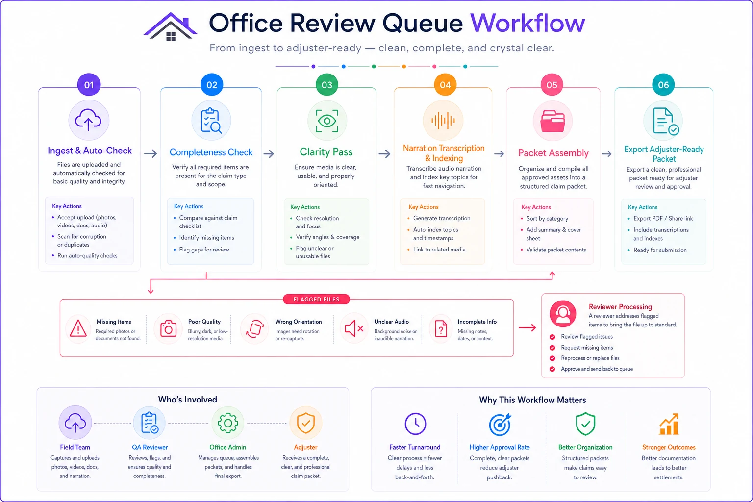
The office review queue
A capture protocol without a review step is just a bigger pile of footage. The review queue is what turns raw flights into finished packets, and it's the part teams almost always skip.
-
Ingest and auto-check. Files land, naming convention applied, geotags validated against the job address. Anything with missing metadata or an address mismatch gets flagged immediately.
-
Completeness check against the shot list. A reviewer confirms all required shots exist — every slope, every penetration, the address anchor, the context pull-back. Missing shots trigger a same-day callback to the crew, not a revisit next week.
-
Clarity pass. Reviewer spot-checks that damage holds are steady and in focus, and that at least one scale reference appears per damage claim.
-
Narration/transcript index. Audio is transcribed or tagged so the packet is searchable by slope and damage type.
-
Packet assembly. Still frames pulled from the strongest holds, annotated, ordered to match the claim structure, exported as the adjuster-ready packet.
This is also where AI-assisted operational tools earn their place — not flying the drone, but handling the tedious ingest work. Modern platforms can auto-apply naming conventions on upload, read EXIF and GPS data to flag any file whose coordinates don't match the job address, run a completeness check against your shot list template, and surface the frames worth reviewing instead of making someone scrub the whole flight. The point isn't automation for its own sake — it's that a reviewer's time goes to judgment calls, not renaming files and hunting for the north slope.
Here's a simple visual of the review queue workflow.
For teams already building supplement documentation, this queue feeds directly into the negotiation workflow. A complete, well-named, geotagged packet is exactly the kind of evidence that holds up when you're pushing back on a lowball scope — something we go into detail on in the evidence-first insurance supplement workflow.
A real scenario
A mid-size residential roofing outfit running storm work was flying drones on nearly every inspection but assembling packets by hand after the fact. Their revisit rate on inspections that turned into claims was running around 1 in 4 — an adjuster would ask for a specific slope angle or clearer hail evidence the original flight hadn't captured cleanly, and a truck went back out.
They locked a fixed shot sequence, put narration scripts on a laminated card in the drone case, standardized naming, and added a next-morning office review pass that checked every flight against the shot list before packets went out.
Revisits on claim inspections dropped to roughly 1 in 12 within a couple months. The bigger win was quieter: packets started going out the same week instead of dragging, which pulled some approvals forward and eased the cashflow lag they'd lived with for years. The drone didn't change. The protocol around it did.
When this level of rigor makes sense — and when it doesn't
This full protocol is worth it if you're doing volume storm or claim work where footage ends up in front of an adjuster. The revisit cost and the negotiation leverage justify the discipline easily.
It's overkill for a quick maintenance look or a homeowner who just wants to see what's going on up there. For those, fly, show them, move on — don't burden a $900 repair with an eight-shot sequence and a review queue.
It's also a bad idea to half-adopt it. A naming convention nobody follows, or a review step that gets skipped on busy days, is worse than nothing because it creates the illusion of a system while the gaps keep costing you. Either commit the whole crew to the sequence and the office to the queue, or don't bother. The value is entirely in the consistency.
The takeaway
Flying a roof is the easy part. The money is in whether that one flight produces a packet nobody has to re-shoot.
Lock the shots, lock the altitudes and geotags, script the narration, name the files so a stranger could sort them, and run every flight through a review queue before it leaves the building. Do that consistently, and the second truck roll — the one that quietly eats your margin and weakens your claim position — mostly disappears.
Ready to elevate your roofing operations?
Join hundreds of roofing contractors using Roofyly to streamline workflows, improve crew coordination, and enhance client satisfaction.