

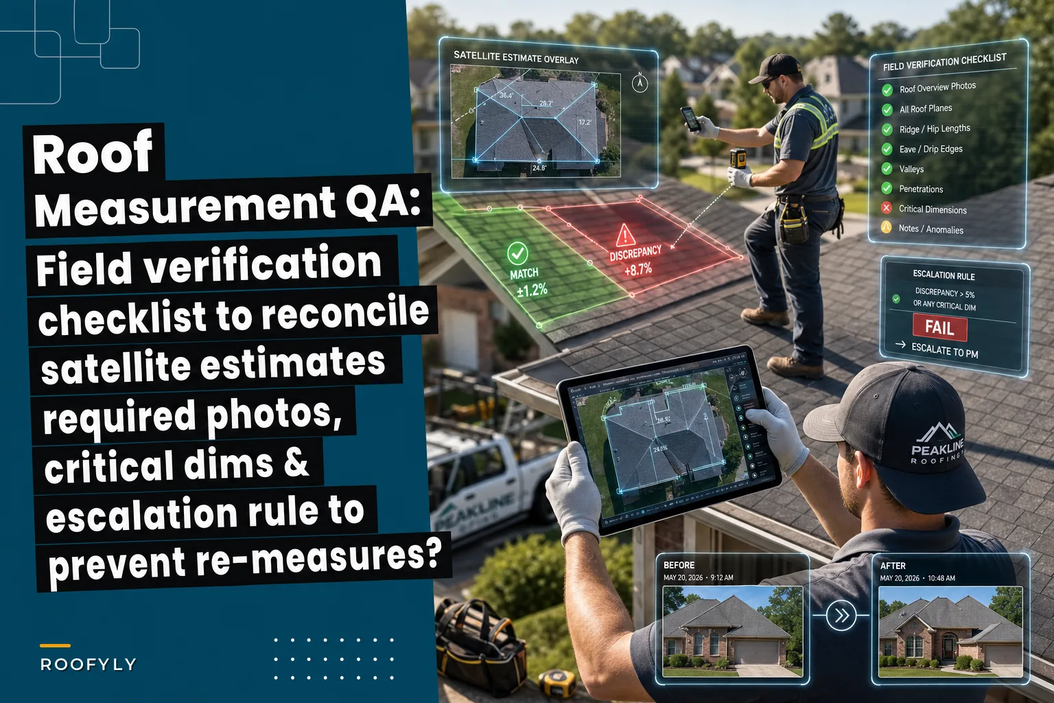

Your estimator pulls up satellite measurements, runs the numbers, sends a quote for a straightforward 28-square reroof. Materials get ordered, crew gets scheduled, everything looks clean. Then your foreman texts you from site: "Boss, this roof has dormers the satellite didn't catch. We're short at least 8 squares."
Now you're scrambling. The supplier needs three days for additional materials. Your crew has to come back next week. The homeowner's frustrated because they took time off work. And your profit margin just evaporated on rush delivery fees and double mobilization costs.
This happens more than most contractors want to admit. Satellite measurement tools have gotten genuinely good over the past few years, but the gap between what satellites see and what crews find on-site still causes expensive surprises regularly. The fix isn't abandoning satellite measurements — they save too much time to give up. The fix is building a verification process that catches discrepancies before materials get ordered and crews get scheduled.
Why satellite measurements miss critical dimensions
Satellite imagery captures roof area reasonably well for simple structures. But roofing complexity lives in details that overhead views struggle to detect.
Tree coverage creates the most obvious blind spots. Mature oaks and maples can completely obscure dormers, valleys, and even entire roof sections. Shadows from neighboring buildings create similar problems, especially on north-facing slopes where satellite images often show nothing but darkness.
Architectural features cause measurement errors even with clear imagery. Low-slope transitions between roof sections get calculated as flat areas. Curved dormers get simplified into rectangles. Cricket installations behind chimneys disappear entirely. These aren't edge cases — most residential roofs have at least one feature that trips up measurement algorithms.
The measurement tools themselves introduce variance. Different platforms use different calculation methods for hip and ridge lengths. Some include overhangs in total square footage, others don't. Waste factor assumptions vary between 10% and 15%. When you're bidding competitively, those differences matter.
Then there's the time lag problem. The satellite image you're measuring might be two years old. Since then, the homeowner added a sunroom, removed a shed dormer, or installed solar panels that completely change your installation approach. These changes only surface when boots hit the roof.
The verification checklist that actually works
After watching a lot of measurement disputes unfold, certain patterns emerge about which dimensions need field verification and which photos prevent arguments later.
Keep every roofing job on track and on time.
Roofyly helps you manage, schedule, and communicate every roofing project with precision and ease.
- Centralized project planning
- Real-time crew notifications
- Integrated scheduling & client updates
No credit card required
Critical Dimensions to Verify:
Primary roof squares need confirmation within 5% of satellite calculations. Have your field verifier pace off the main roof sections and compare to the satellite report. Significant variance here usually points to measurement algorithm problems or image quality issues.
Ridge and hip measurements need special attention — satellites consistently underestimate these by somewhere around 8-12%. Field teams should measure total ridge length with a wheel, not a tape measure. The extra precision matters when you're calculating cap shingle requirements.
Valley measurements create the most disputes because everyone calculates them differently. Measure valleys as actual sloped length, not horizontal projection. Document whether they're open or closed — this affects both material needs and labor time.
Eave and rake edges often get missed in tree-covered areas. Walk the entire perimeter and note any sections the satellite couldn't see. Hidden edges typically add 10-15% to drip edge requirements.
Required Photo Documentation:
Every verification needs four standard angles: one from each corner of the property showing the full roof profile. These overview shots establish what the satellite should have captured versus what actually exists.
Closeup photos of every transition, penetration, and specialty feature prevent scope creep. Get clear shots of chimney crickets, skylight curbs, wall transitions, and pipe boots. Include something for scale — a tape measure or standard shingle works fine.
Problem areas need before-and-after documentation. If the satellite missed a dormer, photograph it from multiple angles. Show how it connects to the main roof. Document the valley configuration. These photos become your evidence when disputes come up.
Escalation Rules:
When field measurements differ from satellite calculations by more than 10%, stop and reconcile before proceeding. Small variances are normal, but double-digit differences indicate systematic problems that will cascade through your estimate.
Document the variance immediately using a standard format: satellite measurement, field measurement, probable cause of difference, and impact on materials and labor. Send it to your estimator within two hours of discovery.
For variances over 15%, require estimator approval before finalizing any quotes. Large gaps like that often reveal fundamental misunderstandings about project scope — better to catch them before the homeowner sees a number.
Before and after: when verification changes everything
A colonial restoration job is a good example of why this matters. Satellite measurement showed 31 squares of dimensional shingles with standard penetrations. Initial estimate came in at $18,500.
Field verification told a different story. The main roof matched satellite calculations, but hidden behind massive oak trees were two shed dormers with copper valleys. The rear elevation included a curved turret section the satellite had simplified into a cone. Actual roof: 37 squares with specialty installation requirements.
Revised estimate jumped to $24,200 — roughly 30% higher. Without that field visit, the crew would have shown up short on materials, unprepared for copper work, and without the right tools for the curved sections.
Another situation involved a ranch home where satellite showed 22 squares of simple hip roof. Field verification confirmed the square footage but uncovered something the satellite image couldn't capture: solar panels installed since the image was taken, covering about 40% of the south-facing slope.
That changed everything about the job approach. Working around solar requires different staging, protection protocols, and coordination with the solar installer for removal and reinstallation. Labor costs increased by roughly $3,500, plus additional fees for solar coordination. The original estimate would have lost money from day one.
The opposite happens too. A commercial property came back at 47 squares on satellite, complicated by what looked like multiple roof levels. Field verification revealed that nearly half the apparent "upper level" was HVAC equipment on platforms, not roof area. Actual roof: 38 squares of straightforward single level. That verification saved the customer a significant overcharge and won the contractor the job against higher bids built on unverified satellite numbers.
Building verification into your standard workflow
Making field verification systematic rather than optional requires operational discipline. Once it's embedded in your process, though, it prevents far more problems than the time investment costs.
-
Anything over $15,000 should get field eyes on it.
-
Any roof with visible tree coverage needs it.
-
Any structure with architectural complexity — dormers, turrets, multiple levels — demands in-person confirmation.
-
Insurance claims always need verification because supplements depend on accurate documentation.
Create a standard verification kit for your field teams. Measurement wheel, 100-foot tape, angle finder for slope verification, and a decent camera or phone with panoramic capability. Add a clipboard with pre-printed verification forms that match your existing estimate format. Consistency in documentation prevents confusion later.
| Standard Verification Kit |
|---|
| Measurement wheel |
| 100-foot tape |
| angle finder for slope verification |
| a decent camera or phone with panoramic capability |
| clipboard with pre-printed verification forms that match your existing estimate format |
Train verifiers on what actually matters. They don't need to remeasure every dimension — just the ones satellites struggle with. Focus their attention on valleys, hips, ridges, and transitions. Teach them to spot signs of recent modifications that won't show on older satellite images.
Here's a simple workflow to standardize verification.
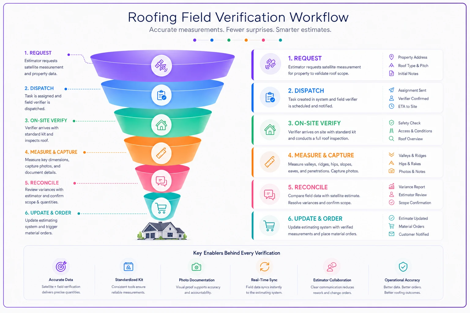
Timing matters too. Schedule verification after your initial satellite measurement but before sending quotes to customers. This gives you time to reconcile differences without delaying the customer response. For insurance work, complete verification before submitting supplements to avoid rejection and rework.
Technology that speeds verification without sacrificing accuracy
Modern operations platforms can streamline verification considerably. Instead of paper forms and manual photo organization, field teams can input measurements directly into mobile apps that sync with your estimating system. Photos get tagged to specific roof sections automatically. Variances trigger alerts to estimators right away.
Tag photos to specific roof sections in the app as you take them to avoid later sorting and speed dispute resolution.
The key is choosing tools that fit your existing workflow rather than replacing it. Your team already knows how to measure roofs. Technology should make that knowledge more efficient, not obsolete.
AI-powered analysis helps identify which properties need verification most urgently. By comparing satellite imagery age, tree coverage, and architectural complexity, these systems can flag high-risk measurements before you invest time in quotes that will need major revision. Some platforms now combine satellite measurements with drone footage and ground photos to build more complete roof models — they don't eliminate the need for verification, but they do reduce surprises and help focus where human review should go.
Integration between verification data and your other operational systems matters a lot here. When field measurements update, material orders can adjust automatically. When photos document additional work, change orders generate without manual entry. That connected approach means verification actually saves time rather than just adding steps.
Verification as competitive advantage
Most roofing contractors treat measurement verification as an annoying extra step. They run with satellite numbers until something goes wrong, then scramble to fix problems on-site. That reactive approach burns through profit margins and frustrates customers.
The contractors who build systematic verification into their operations tell a different story. Their quotes are more accurate. Their material orders are right the first time. Their crews show up prepared for what they'll actually find. Customers trust them because promises match reality.
The checklist and process here isn't complicated. It requires no special expertise beyond basic roofing knowledge. It does require operational discipline — the commitment to verify before you quote, document before you promise, and reconcile before you proceed.
In an industry where margins are tight and competition is fierce, accuracy becomes a differentiator. The contractor who shows up with the right materials, prepared for the actual job, and delivers what they promised wins repeat business and referrals.
The investment is minimal — maybe two hours per job for verification, photography, and reconciliation. The return is fewer re-measures, eliminated material shortages, reduced crew downtime, and customers who get exactly what they expected. Those advantages compound quickly into measurably better business performance.
Ready to elevate your roofing operations?
Join hundreds of roofing contractors using Roofyly to streamline workflows, improve crew coordination, and enhance client satisfaction.